Honest Answers for SANTA CRUZ County
There is a long-running debate regarding the best use of the Santa Cruz Branch Line rail corridor from Watsonville to Davenport. Below is a set of honest, factual answers so that Santa Cruz County residents can assess the data and make their own decisions.
We all make trade-offs in how we spend our time and money and this is another important public policy question where each of us must answer that question with honest information because every dollar spent on one project takes a dollar away from another project.
What are the core arguments for a greenway vs. a train?
Advocates of passenger rail on the Santa Cruz Branch Line believe it will provide another mode of transit between Watsonville and Santa Cruz by 2045. Their plan includes building a trail next to the railroad tracks, but width and environmental constraints mean that such a “trail” will detour off the rail line onto unsafe streets and roads (such as the Harkins Slough detour onto San Andreas Rd and W. Beach St). The rail plan provided by the RTC also claims a train on the corridor would cost $1.3 billion over 30 years and new taxes would need to be passed by two thirds (66.7%) of county voters to fund it. No specific plans have been articulated to fund the rail plan, which is why it is never any closer to realization.
Greenway advocates for a wide multi-use greenway in the middle of the corridor and transit solutions that utilize the existing METRO bus system, with improvements such as bus-on-shoulder on Hwy 1 and Adaptive Signal Control on Soquel/Freedom to expedite north/south buses. Nationally recognized transportation consultant Nelson Nygaard has shown that a greenway that uses the entire width of the corridor with separate lanes for bikes and pedestrians can move 8,000 new cyclists per day[1] vs. 1,500-2,500 estimated daily roundtrip train riders.[2] Another nationally recognized transportation consultant, Alta Planning and Design, has shown that a 21 foot wide multi-use greenway with separate lanes for bikes and pedestrians has 5.8 times the capacity of a 12 foot wide trail.[3] Bus on Shoulder on Hwy 1 and improvements for METRO buses on Soquel/Freedom are funded by Measure D and expected to be finished in stages from 2023-2026.

Depiction of Greenway
Why doesn’t traffic significantly decrease on Hwy 1 if a train is built?
The average forecast for train ridership is 2,000 roundtrips per day; only about 300 of those are from Watsonville. There are about 117,500 “roundtrips” per day on Hwy 1 (pre-pandemic: 118,000 daily northbound and 117,000 daily southbound),[4] so taking 1.7% of cars off Hwy 1 will not significantly impact traffic.
Hwy 1 traffic is composed of many types of commuters who live in various locations. Many are not candidates to take public transit:
Commuters originating from Monterey or San Benito County (e.g. about half of Hwy 1 traffic passing north of Watsonville originated in Monterey County)
Commuters needing their personal vehicles (e.g. trades, equipment, flexibility, child care, odd hours, safety, etc.)
Commuters taking Hwy 17 to Scotts Valley or Silicon Valley (⅓ of northbound Watsonville commuters)[5]
Can you have both a train and trail on the rail corridor?
The honest answer is “only for part of the trail” due to infrastructure and environmental constraints. Also, the cost of duplicating 24 bridges and building large retaining walls is so significant there will be insufficient funding to build a trail. Already, lack of funding is dooming many parts of the trail (e.g. Segments 9 & 10).
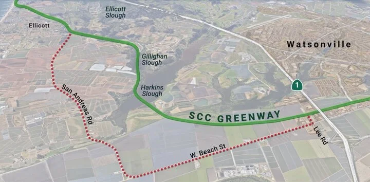
Watsonville does not get a trail outside the city limit in the RTC’s proposed plan. South County gets 1.2 miles of trail from Lee Rd to Walker St. After Lee Rd, the “trail” detours for nearly 5 miles onto W. Beach St and San Andreas Rd due to environmental and physical constraints in Harkins Slough. Both roads are not safe alternatives as cars travel up to 60 MPH with a deep drainage ditch on W. Beach running alongside the road.
By contrast, the City of Santa Cruz built the first completed 1.3 mile segment for itself. It plans to add 1 mile of trail from California Ave to the Santa Cruz Wharf, completing all the segments in the city limit (not funded).
Besides its political power to put itself first in line, the one segment built so far in the City of Santa Cruz is a relatively wide corridor with few environmental constraints, thus reducing cost and increasing feasibility. Thereafter, the cost and feasibility of a train and trail side-by-side become extremely problematic, as shown below where there is an inability to build a train and trail together through Harkins and Gallighan Sloughs, or similarly across the Capitola Trestle, necessitating a detour through heavily congested Capitola Village.
Red dots show proposed RTC south county “trail” detours onto unsafe roads. Greenway’s safe & beautiful path (the green line) would follow the actual rail corridor.
Does a train provide social equity?
Train routes are generally designed by those in power, and as such, most trains serve higher income residents. When you look at the projected ridership from RTC studies, the proposed train in Santa Cruz County is no exception. Experience from around the U.S. supports this conclusion.[6,7,8] Stations are also primarily located in north and mid county, having 9 proposed stations versus 2 in Watsonville and Pajaro.
To pay for a train, a regressive sales tax will be imposed on ALL taxpayers, especially on those least able to afford it, to fund a transit system benefitting the affluent. In other words, the proposed sales tax would take a larger percentage of income from low-income taxpayers than from high-income taxpayers. Already, the City of Watsonville is at its maximum sales tax by law without a specific state exemption to increase it. With projected ridership from Watsonville so low, it seems hardly fair to impose a regressive sales tax for a few highly subsidized train riders.
In addition, there are very few recreational opportunities in Watsonville, particularly for young people. For example, there is no public pool and limited neighborhood parks. With the RTC plan to detour nearly 5 miles of “trail” off the rail corridor onto W. Beach St and San Andreas Rd, there will be no trail for Watsonville providing access to beaches or some of its most beautiful areas like Harkins Slough.
Health is a big part of social equity. The ability to exercise, get fresh air and be in nature is part of having good health, which is why over 150 health professionals endorse Greenway.[9]
Social equity in Santa Cruz County should start with a discussion around local jobs and economic development in Watsonville rather than serving the City of Santa Cruz’s low paid service sector, affordable housing throughout the county to avoid increasing gentrification in Watsonville, a fair share of tax dollars and investment from the county to improve food security, healthcare, education, high speed internet access and the existing public transit system — METRO!
How much does a train with trail cost?
The RTC’s cost estimate of the proposed train has risen from $700M in 2015[10] to $1.3 billion in 2018 ($500M capital and $800M in operating expenses over 30 years).[11] Optimistic grant projections forecast funding for only 59% of capital and 45% of operations and maintenance. In addition, farebox recovery for rail systems like Sonoma Marin Area Rail Transit (SMART) is around 15% of annual operating costs, so applying that metric to Santa Cruz County it would mean a public subsidy of 85% or $680M from county tax payers.[12] The subsidy will conservatively require a ½ cent sales tax be passed by 2/3s of county voters to support 1,500-2,500 roundtrips per day,[13] serving mostly north county passengers according to RTC studies. Subsidies for SMART are $50 per rider per day.[14] Sonoma and Marin county voters rejected an extension of the SMART sales tax in March, 2020. It’s important to note that Sonoma and Marin counties have a combined population three times that of Santa Cruz County, and the SMART train has proven financially infeasible (before the pandemic!).
The cost of a trail built next to the tracks ranges widely depending on whether there is enough room for construction. The narrower the physical contour of the corridor the more expensive the cost. The City of Santa Cruz’s 1.2 mile Segment 7, Phase 1 (the easiest to build) cost $6.4 million per mile.[15] The cost of the first mid-county section is currently forecast to be $14 million per mile.[16] The cost of greenway is much cheaper, projected at $2-3 million per mile, as a greenway plan would use all the existing trestles and infrastructure.
How far are proposed train stations[17] to major employers?
Factors NOT calculated into “commute times” that are quoted by train proponents are the first mile/last mile time and cost. Whereas a bus or car may be point to point commuting, a train is on a fixed rail line with stations. One needs to consider that another bus, taxi, or rideshare will be required to get to and from each train station from home or work. If using a bicycle for the first/last mile, there is no added cost but there is a time consideration.
| Driscoll’s to Downtown Watsonville Station | 1.9 miles |
| Cabrillo College to Cabrillo College Station | 1.1 miles |
| Capitola Mall to 41st Ave Station | 0.7 miles |
| Home Depot to 41st Ave Station | 1.2 miles |
| Dominican Hospital/Medical Offices to 17th Ave Station | 2.0 miles |
| County Bldg on Ocean St to Seabright Station | 1.4 miles |
| County Bldg on Emeline St to Downtown SC/Boardwalk Sta. | 2.3 miles |
| Boardwalk to Downtown SC/Boardwalk Station | 0.5 miles |
| Downtown Santa Cruz to Downtown SC/Boardwalk Station | 0.6 miles |
| Costco to Downtown SC/Boardwalk Station | 1.7 miles |
| Plantronics to Downtown SC/Boardwalk Station | 2.0 miles |
| Santa Cruz Nutritionals to Natural Bridges Station | 0.6 miles |
| UCSC Cowell College to Natural Bridges Station | 3.3 miles |
The implication of the distances from train stations to employers above is that commuters will need to arrive at stations before departure time (via drop-off, rideshare, bus, car + parking, or bike) and then allow for additional commute time to their employer once they arrive at the closest train station. For an apples-to-apples comparison, commuters will need to calculate their TOTAL time and cost for commuting via train including the first and last mile.
How much are train fares from Watsonville to Santa Cruz and back?
The average fare currently predicted by the RTC is $4.50 one-way or $9.00 roundtrip.[18] By contrast, the actual fare for a 20 mile trip on SMART (3 zones) is $7.50 one-way or $15.00 roundtrip.[19] SMART offers half price discounts to seniors, youth and passengers with disabilities. So the monthly cost for 22 business days to commute on the train would look like this, including an allowance for first/last mile cost @ $2.00/day. Can the average Watsonville resident afford to spend $242 to $374 per month for train commuting?

Can you compare a train, bus, and e-bike commute time and cost from downtown Watsonville to downtown Santa Cruz?

Why is Watsonville train ridership projected to be so low?
The Passenger Rail Feasibility Study showed projected ridership to be very low for Watsonville commuters. Why? Ridership is estimated using a “catchment” area considering the population surrounding a proposed train station. For Watsonville, the proposed station is located in a mostly industrial neighborhood. This makes sense for moving freight. However, the location does not bode well for passenger service as it’s not located near population centers and would be inconvenient to access for most residents. In addition, high fares, first/last mile time and cost, and the distance of train stations along the line to the main county employers expose the dubious claim of social equity for a train.
The chart below shows Watsonville roundtrip train ridership at about 300 per day. By contrast, most train passengers are in north county. Would it be better to spend $1.3 billion on other community needs like addressing the digital divide, affordable housing, parks, education and health care?
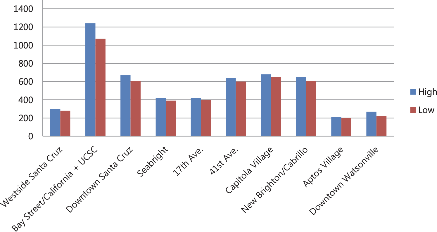
Source: SCCRTC Rail Transit Feasibility Study, pg. 114
Won’t a train slow down street traffic?
YES! There are 38 street crossings from Santa Cruz to Watsonville. Many street crossings are major arteries servicing how people get around the county, including Lee Rd, W. Beach, Ohlone Parkway, Walker, Monterey Ave, Trout Gulch, 47th, 41st, 38th, 30th, 17th, 7th, Seabright, the Wharf, Almar, Fair and Swift. All of these streets and many more will see traffic slowed as 30-60 trains per day go by.
How many buses run each day between Watsonville and SC?[25]
The main bus line from Watsonville to Santa Cruz is #71 and runs every 20-30 minutes Monday-Friday. There are 32 buses in EACH direction Monday-Friday. The Express Bus, 91x, runs every hour and there are 10 buses in EACH direction Monday-Friday, mostly geared around commute times. On the weekends, there are 24 buses in each direction on the #71 line and no express buses.
What improvements are planned for METRO in the near future?
The RTC is working to implement Bus-on-Shoulder on Hwy 1, whereby buses ONLY would be permitted to use the shoulder of Hwy 1 to bypass traffic during commute hours. Bus-on-Shoulder will reduce wait times in commuter traffic. In addition, the RTC is planning to implement improvements on Freedom/Soquel to speed buses through traffic lights using Adaptive Signal Control. Both of these efforts will be primarily completed in the next 5 years (vs. 24 years for a train according to the RTC or much more likely — never).
Will my children be safe on a trail a few feet from a train?
Trains can be a major safety issue for children, with 30-60 trains per day moving at 45-60 MPH through neighborhoods, only separated from children by a 4.5 foot high wire fence easily hopped through. Since SMART was started in 2017, there have been 12 deaths (combination of accidents and suicides).
What kind of environmental impact will building a train entail?
The environmental impacts from building passenger rail through the community are significant. To build the retaining walls, vast amounts of earth will be moved, habitat and wildlife permanently disturbed, and hundreds of heritage trees cut down (largely, majestic oak trees).
The Santa Cruz County Coastal Climate Change Vulnerability Report[26] is also recommending that heavy infrastructure be moved away from the coast due to sea level rise. We would be doing just the opposite, investing $1.3 billion in heavy infrastructure in flood zones and along the coastal bluff (e.g. Schwan Lake, Manresa, La Selva) at exactly the time any NEW heavy investments should be moving inland.
Finally, noise is a huge environmental impact. When initial rails were laid down a hundred years ago, our community looked completely different. Now a train will pass throughout the county within feet of residents’ homes with associated noise increases.

Hundreds of beautiful heritage trees like this oak will be cut in the current RTC plan.
Why is the train so pro-development?
There have been major fights in Santa Cruz County over the years against inappropriate development (e.g. Lighthouse Field, north coast, Wingspread near New Brighton State Park). Train advocates talk about “transit oriented development” (TOD). These are cool buzzwords when applied to large urban settings like the Bay Area, New York or Chicago. It essentially means to cluster apartments and housing around transit lines to cut down on car trips and facilitate easy commutes to jobs. It works in cities with millions of people. If you want a glimpse of TOD, drive over the hill and look at all the 5-7 story apartment buildings going up along the CalTrain line in Burlingame, San Mateo, Menlo Park, Palo Alto and Mt. View. When CalTrain gets closer to major cities like San Francisco and San Jose, the height of the apartment buildings increases to 20-50 stories. So imagine this type of development along the rail corridor! Is this the type of development we want around the 11 proposed train stations in Santa Cruz County? The TOD argument envisages a dramatically altered Santa Cruz County, with tens of thousands more people and major gentrification in Watsonville. Is this a good vision for appropriate development in a small county like ours?
Why have three different freight rail operators quit since 2012?
Since 2012, three different freight rail operators (Sierra Northern, Iowa Pacific and Progressive Rail) have terminated their contract with the Regional Transportation Commission (RTC) due to an inability to make money on the Santa Cruz Branch Line. The most recent failed operator is Progressive Rail, who lasted only two years after making many promises and being lauded by train supporters as the ideal operator. There are four businesses (Del Mar Food Products, Lineage Logistics, Agron Bioenergy and Big Creek Lumber) that use freight services south out of Watsonville and the RTC is now looking for an operator that will serve these businesses. It is clear after the last nine years that the Santa Cruz Branch Line north of Watsonville is no longer financially viable for freight.

What new transportation technologies are around the corner?
Transportation technologies are changing rapidly. In the timeframe of a train (RTC says 2045), everything will change. In the last few years we have seen the development of vertical take-off commuter planes from a local company, Joby Aviation. E-bikes have followed the technology curve of cheaper, better and faster every year. Elon Musk has started his boring company to move transit underground. We are on the verge of electric self-driving cars from multiple manufacturers. And much more… We should be making investments now that have tangible benefits for the residents in the medium-term, since none of us can know what the future will bring...but we KNOW it will bring innovation that we haven’t thought of yet.
Compiled by Santa Cruz County Greenway. Questions or comments can be sent to: info@sccgreenway.org
We welcome corrections. Please include references.
Endnotes
Presentation to Kimley Horn, Potential Total Daily Cyclist Usage, Mid-Point Estimate, slide 35, August 2017
SCCRTC Transit Corridors Alternatives Analysis, Table 5.1, page 5-18, January 2021
Analysis of SCC Greenway Capacity and Usage, Alta Planning and Design, February, 2018
Average daily Hwy 1 roundtrips between Santa Cruz/Monterey County line and the Hwy 1/Hwy 17 interchange was derived by summing Highway 1 on-ramp counts and traffic at county line for 2017.
Hwy 1 north Watsonville commuters determined by analysis of Home-to-Work tabulations provided at the United States Census Bureau (onthemap.ces.census.gov) using input “Watsonville” (city), “Perform Analysis On Selection Area”, “Destination” for Analysis Area, and “All” for Display Settings” to see “Jobs Counts By Places” in the right pane.
New figures show decline in number of low income workers who ride Metro; Washington Post, December 18, 2018
Study: High fares make commuter rail too costly for many residents; Boston Business Journal, September 5, 2019
Seattle’s higher earners are more likely to commute on public transit than any other income group; Seattle Times, October 8, 2018
SCCRTC Passenger Rail Transit Feasibility Study, page 126, Table 6-19. O & M costs scaled to 30 years to reflect the time frame of a sales tax measure similar to Measure D and rounded to $700M for uncovered costs including financing, parking, fences, quiet zones and 40% average cost overruns.
SCCRTC Unified Corridors Investment Study Page B-11 and B-12, Table B-10. Electric train cost noted in footnote 2 on page B-11
SMART 2019 Strategic Plan, page 31: 2019 Revenue of $41M, of which fare box is $5M or 14% of total revenue (86% subsidy)
SCCRTC Transit Corridors Alternatives Analysis, page 5-18, Table 5.1, January 2021
SMART ridership data: 2019 Revenue of $41M - $5M farebox = $36M / ridership of 716,800 = $50 subsidy per rider; see footnote 6 and SMART Ridership Reports
SCCRTC Transit Corridors Alternatives Analysis for proposed station locations, page ES-17, Figure ES.3, January 2021
SCCRTC Transit Corridors Alternatives Analysis, page 5-29, January 2021
Not So SMART: Why SMART is a Bad Model for Santa Cruz County
Note that all commuters cannot secure a discount, and in the case of SMART, it applies only to seniors, youth and those with disabilities.
Train fare range based on preceding chart. Bus fares from RTC website. Bus has discounted fares ($3 vs. $4 roundtrip) and a train will likely have discounted fares a la SMART.
SCCRTC Transit Corridors Alternatives Analysis, Table 5.1, page 5-18; 43 minutes is midpoint estimated travel time plus 20 minutes first/last mile travel and waiting time, January 2021
SCC METRO Trip Planner, #91 departing 7:05am, arriving 8:15am; SCC METRO Trip Planner, #91 departing 3:25pm, arriving 4:20pm; AM trip time of 70 minutes and PM trip time of 55 minutes are averaged for trip time of 63 minutes.
E-bike trip on county streets and roads from Santa Cruz to Watsonville on different routes each way was timed in January 2021, with biking at a moderate pace with a pedal assist e-bike in eco mode. Each trip took 70 minutes. It is expected that both one-way travel times will decrease 10-15 minutes on the greenway, due to less grade, more direct route, and no traffic lights or cars. It will also be MUCH safer.
Santa Cruz County Coastal Climate Change Vulnerability Report, Central Coast Wetlands Group, Moss Landing Marine Labs, June 2017