
Trail Width, Fences, Retaining Walls, And Vegetation
Trail-Only vs. Rail-With-Trail: Width Matters
A trail is going to be built in the unused rail corridor in Santa Cruz County. There are two basic options: rail-with-trail, where the unused tracks are left in place or trail-only (also known as Greenway), where the tracks are removed or covered leaving the entire space available for paths. It is time for people in Santa Cruz County to choose.
A simple and primary measure of any path or trail’s usefulness is its width. Narrow trails often require people on foot to mix with people on wheels. On low traffic trails, people may conveniently avoid each other. As trails become more heavily used and as differences in speed increase, narrow trails become unsafe, inconvenient, and less likely to provide transportation.
The Santa Cruz County Regional Transportation Commision (RTC) has not examined the differences between the two types of trails. To help further the discussion, Santa Cruz County Greenway hired Alta Planning + Design to create engineering drawings showing the differences between the two types of trails. Alta Planning is a preeminent designers of trails in the United States, having worked on more greenway and trail projects than any other firm in North America.
Three locations on the corridor were chosen. The three locations are typical of the section of the corridor in the most densely populated section of the corridor:
Tree Tunnel at Park Ave
Capitola Trestle
41st Ave

These 3 examples are far from exhaustive. For such a relatively short rail line (about 32 miles), it is remarkably complex terrain with numerous bridges and trestles crossing steep ravines, creeks, Harkins Slough, and the harbor, a variety of vegetation and heritage trees, steep slopes, and many soil types. We’ve chosen these three locations because they illustrate some of the most common issues.
These locations are also easily accessible and we encourage anyone interested in our corridor to visit these locations and others. There is nothing like seeing it for yourself to understand the issues.
1. The “tree tunnel” next to Park Avenue in Capitola
The tunnel of trees in Capitola stretches from views of the Pacific and New Brighton beach to Monterey Ave. It is lined with heritage oak trees, eucalyptus, and a variety of plants and vegetation. This section of track is typical of areas where the tracks cut through a hillside before crossing a creek. The focus is issues with trees and retaining walls.
The Site Photo and drawings look west towards the Capitola Trestle.

Tree Tunnel — Site Photo
The corridor cuts through a hillside with both sides being quite steep. The southern side (left in the Site Photo) is high, about 20 feet, with houses at the top. The northern side (right in the Site Photo) is less steep and rises about 8 feet to Park Ave. As evidenced by the paths, people regularly walk on both the track bed and next to the tracks.

Tree Tunnel — Existing Condition
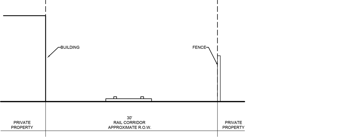
Both the Site Photo and the Existing Condition drawing show that the corridor was created to be just wide enough for a train. This narrow space can be found all along the corridor, both where it cuts through hillsides and where it is laid on top of manmade embankments over low areas. Those who designed and constructed the corridor, made it just wide enough.
It’s important to note that even though the right of way (ROW) is 50’ wide, the current usable space is 19’.

Tree Tunnel — Rail-with-Trail
Squeezing in a trail next to the rail is tough with numerous issues::
Only the northern side next to Park Ave has enough space without moving the tracks.
A large amount of earth needs to be removed to add a trail.
A tall and long retaining wall would be built.
Much vegetation including heritage oak trees and eucalyptus trees would be removed. (It should be noted that an operating passenger train would also likely require removing additional large trees due to safety regulations.)
The width is only large enough to add a narrow path that mixes pedestrians and riders after extensive earth removal and building a large retaining wall.
The single path at 10’ is only slightly wider than the minimum recommended width of 8’.
A fence is required to separate people from the unused tracks and will divide the community of Capitola in half.
Besides the obvious expense, limited usability, and impact on trees and vegetation, the fence and retaining walls severely limit access to the path. Currently, people have created paths from Park Ave down to the corridor. While it would be possible to engineer steps through the retaining wall and down to the path, the complexity would make trail construction even more expensive.
The fence would prevent people walking along the cliff above New Brighton from easily accessing the path. Instead, they would need to walk to one of the relatively infrequent roads that cross the tracks. Essentially, the fence will divide Capitola in half.
Because of the narrow width and the high cost and disruption of retaining walls, some rail-with-trail plans show the trail leaving the rail corridor and using Park Ave.

Tree Tunnel — Trail-Only
The trail-only option advocated by Greenway is dramatically simpler:
Trees and vegetation are untouched.
Trail width is increased from 10’ to 14’ providing space for bi-directional active transportation separated from groups of people walking.
The trail could be constructed on top of the existing tracks (like sections of the rail-trail in Monterey) or the tracks could be pulled and replaced by the trail.
The simplicity results in a lower cost, impacts vegetation and terrain less, and yet results in a path that is much more usable for both people on foot and people on wheels.
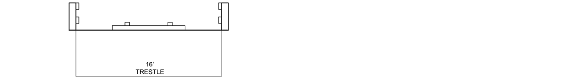
2. The Capitola Trestle
The iconic Capitola Trestle presents the most dramatic differences between rail-with-trail and trail-only.

Capitola Trestle — Site Photo
Although the trestle has been used for decades by pedestrians, leaving the tracks in place and creating a rail-with-trail would completely close the trestle to people walking as well as present one of the greatest challenges for active transportation.
Capitola Trestle — Existing Condition
The narrow width of the trestle presents essentially no option for a trail if the tracks are left in place. Acknowledging the difficulties of a trail on the limited space, current plans detour the trail down through the village. Detouring through the village eliminates a primary reason for rail-trails: the relatively flat path with a maximum 3% grade that old train tracks provide. It also creates significant safety issues moving potentially thousands of users through heavily trafficked Capitola Village. It creates access problems for those with disabilities going up and down steep roads. And it goes against the express wishes of Vision Capitola and community interests to not increase traffic in the Village.

Capitola Trestle — Rail-with-Trail Detour
To keep the tracks in place on the Capitola trestle, the rail-with-trail option has cyclists, pedestrians, and wheelchair users exit the trail and travel downhill on Cliff Drive, traverse busy Capitola Village, and then climb a steep hill on Monterey Avenue to rejoin the path on Park Ave.

Capitola Trestle — Trail-Only
The trail-only option is the only option for the Capitola Trestle. The engineering is relatively simple. The result would be a beautifully easy path to walk and ride with stunning views of Capitola and ocean vistas.
3. 41st Avenue
The corridor around 41st Ave is typical of sections that go through the relatively densely populated central reach.
In the short 5 miles between Capitola and the Santa Cruz Beach Boardwalk, the corridor:
crosses 7 roads and 4 creeks, streams or other bodies of water;
has numerous side streets butting up against the corridor often without fences;
and is hemmed in by small businesses, homes, parks, and schools.
This section is narrow and with complex terrain but is likely to be the most heavily used section of the corridor for both active transportation and recreation.

41st Ave — Site Photo
The Site Photo looks west towards the crossing at 41st Ave with O’Neils surf shop on the right side in the distance. Immediately to the right is a spa and to the left medium density housing. As with so much of the tracks, people have created paths both next to the track and down the middle of the tracks.
41st Ave — Existing Condition
The ROW is completely used by the existing corridor. There is little space for the tracks much less for tracks and a trail.

41st Ave — Rail-with-Trail
To allow both tracks and trail, the tracks must be moved. The drawing shows the track centerline moved to the legal minimum 8.5’ setback from buildings. The remaining space allows for only an absolute minimum width path. Such a path cannot support active transportation along with pedestrians in anything but the most limited capacity.
The new fence—which is required to separate the unused tracks from the path—would prevent access from streets on the southern side of corridor.

41st Ave — Trail-Only
The trail-only option provides for two wide paths: a path for active transportation and a path for pedestrians. Bike riders can easily pass each other at high speed without interacting with people on foot. The wide pedestrian path allows people to walk side-by-side as well as with their dogs. The lack of a fence means the people can enter the corridor from both the north and south sides as well as easily visit shops, parks, schools, and the hundreds of other desirable locations along the way.
References
Highway Design Manual, Chapter 1000 Bicycle Transportation Design—CA DOT, 2017
Evaluation of Safety, Design, and Operation of Shared-Use Paths [PDF]—Describes the development of a new method to analyze the quality of service provided by shared paths of various widths and the accommodation of various travel–mode splits. Federal Highway Administration Research and Technology, June 2006.